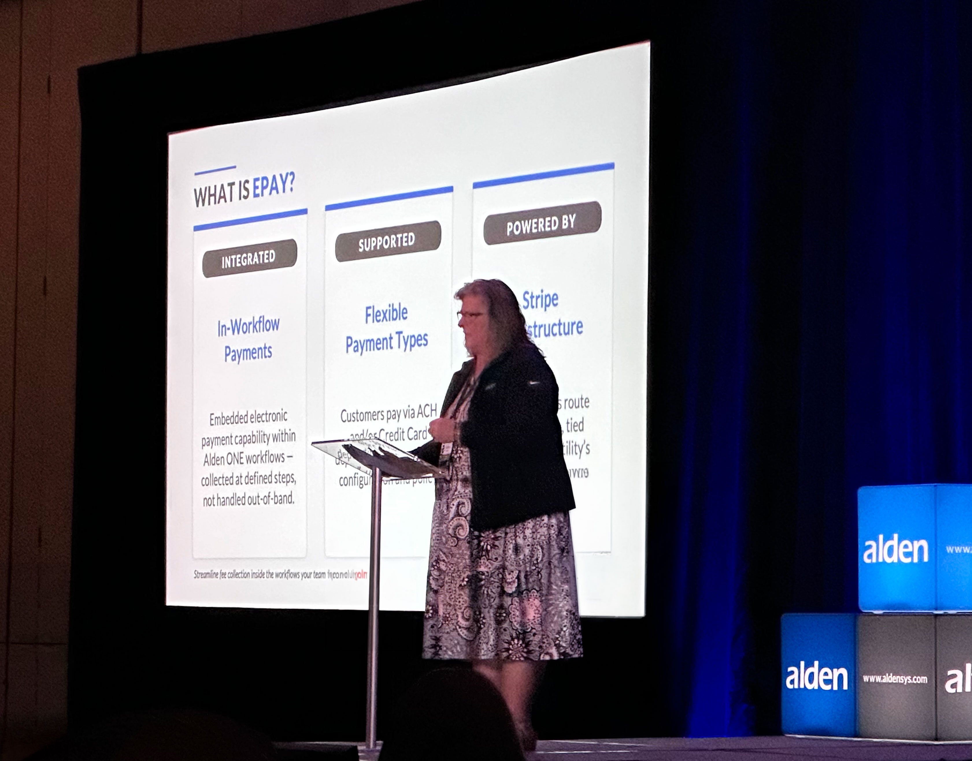
How the Switch to 5G is Driving an Increase in LiDAR Mapping

Posted by Ashley Little on June 15, 2020

5G Cell Tower

Across the country today, the broadband industry is working fervently to bring 5G service to a massive number of Americans.

For the consumer, 5G will mean speeds and bandwidth far eclipsing what 4G offers. Beyond that, it will continue to build on the foundation of the Internet of Things (IoT), allowing vast expansion of sophisticated home automation, smart city technology, and autonomous vehicles throughout our society. Eventually, IoT is likely to transform personal health devices, traffic flow, public safety, public parking, energy systems, and many other aspects of public and private life. 

For companies rolling out this exciting technology and competing with one another to do it first and best, the greatest need is for speed. The more people hear about 5G, the more they want it now. The complicating factor is that to work properly, 5G demands a much denser communications infrastructure than currently exists in most places. A cell tower every three to five miles doesn’t get the job done.


5G Data Demands

5G frequencies require an antenna every 300 to 700 feet. Many of the units being attached range in size from a backpack to a small refrigerator with an antenna protruding.

With the average utility pole spacing, an attachment is required on roughly every fourth or fifth pole to support 5G. This process requires coordinating with other asset owners like utility companies and municipalities and filing permit applications to attach communications equipment, which means gathering a lot of data first.

Companies need to know where poles are available, which poles are already loaded with attachments, and where new poles may be needed to fill in gaps. They also need to know about any possible obstructions in the vicinity that could interfere with 5G signals.

These needs are driving asset data collection at a level not seen before. Just as service providers need to figure out where they can place equipment, utilities need up-to-date data to make sure the proposed attachments do not cause safety issues or overload poles. Despite eagerness to move quickly, many companies find themselves facing a bottleneck.

A valuable tool is available to help gather data quickly, and more and more companies are turning to it: LiDAR.

What is LiDAR mapping?

LiDAR (Light Detection and Ranging) is the technology employed for decades by the military and law enforcement, but in the last few years it has begun to be used for many other purposes as the costs gradually decreased. Fields as diverse as agriculture, archaeology, pollution modeling, and flood planning are benefiting from LiDAR mapping, as reported by Geospatial World.

LiDAR works by emitting up to a million pulses of laser light per second, invisible to the eye, that accurately measure distances to everything in their field. That data can be used to create what is known as a “Digital Twin,” an accurate representation of what a person onsite, looking at the infrastructure, would see.

LiDAR devices can be handheld or attached to a vehicle, drone aircraft, helicopter, or fixed-wing aircraft. Often multiple forms of LiDAR, as well as more traditional data collection methods, will be used for any given mapping job.

Especially when combined with digital photography, LiDAR can efficiently map miles of utility and municipal infrastructure to give the client an accurate picture of where opportunities for attachment exist and where additional structures are needed.

Benefits of LiDAR

LiDAR data usually is supplemented by ground crews gathering additional information, but the process overall remains much faster than relying on hand-gathered data alone.

The need for accurate intelligence on infrastructure to deploy the 5G network is critical. The rollout is expected to continue through much of the 2020s. Infrastructure is changing so fast that mapping will need to be repeated frequently over the next few years to keep data up to date.

While LiDAR maps infrastructure for 5G deployment, the information it supplies can serve other useful purposes. It can spot tree limbs encroaching on assets, assisting in vegetation management. Through thermal imaging, it can identify equipment that’s running too hot and may be in danger of failure.

The speed gains of LiDAR aren’t limited to collecting data in the field. With the right management system, LiDAR data can be compiled quickly and efficiently so it’s ready to use and, if desired, easy to share.

The Alden Advantage

At Alden, we offer a range of data collection methods to suit your needs, from “boots on the ground” manual collection to LiDAR, or a combination of methods. We’ve built a platform, Alden One®, where all asset information collected in the field is pulled together so it’s ready to use for permit applications, utility pole load analysis, vegetation management, or other purposes. There is a great advantage in sharing data you collect to improve interactions with all stakeholders, internal and external to your company.

Alden One® is the perfect tool to break the 5G bottleneck. It automates the process to track applications and approvals, prevent missed deadlines, and keep payment and billing information current. Alden One® ensures everyone who’s involved -- attaching companies, asset owners, contractors, and multiple departments within a company or city government -- on the same page. The central platform helps avoid the confusion that can come with an intense undertaking like 5G deployment.

5G is placing big demands on the joint use community. With the best technology available, we can work together to make the rollout happen and get it right.

If you’d like to know more, click here to contact a product specialist.

Placeholder (Update When CTA Is Approved)

Tags:

Comments