Utilizing an Active Fire Mapping Program for Utility Asset Maintenance
2017 was one of the worst years on record for wildfires in the Western U.S. According to a report from NPR; there were 123 large wildland fires burning on about 2 million acres of land in California, Oregon, Washington, and Montana during 2017.
Satellite images from 2017 show a huge swath of smoke stretching across the country from the Pacific Northwest to the Great Lakes.

A NASA satellite image from The Washington Post
(image source: www.washingtonpost.com/news/capital-weather-gang/wp/2017/09/06/wildfires-ravaging-the-western-u-s-smoke-sprawls-across-the-nation/?utm_term=.26f121fb6291)
Trends have shown that the fire seasons become worse over the years, a trend developing for several decades. Some fires (but not all) have been caused by utility poles and wires.
It is critical for pole owners to have the tools to manage and maintain assets in high fire-risk regions.
As we discussed in another post, most asset owners do not currently have the tools needed to effectively manage their plant resourcefully. A tool is needed that can combine asset data (location, condition, number and names of attachers) with appropriate boundary data; the tool is a centralized joint use platform like Alden One®.
Fire Mapping: A Valuable Resource for Asset Owners

(image source: www.justinholman.com/wp-content/uploads/2012/06/Statewide_fire_risk_final.jpg)
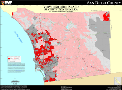
(image source: frap.fire.ca.gov/webdata/maps/san_diego/fhszl_map.37.jpg)
These maps and related planning efforts help states to reduce firefighting costs and property losses, increase firefighter safety, and contribute to ecosystem health.
How Utility Asset Owners Can Use Fire Mapping
In the case of an active wildfire, asset owners could use data to identify zones where fires or other natural disasters are likely to occur and ready themselves for faster restoration.
Wildfire Updates in Real-Time
Making Preventative Measures a Priority
For instance, ceasing tree pruning and removal activities when fire season is likely, would decrease a chance of detached trees catching fire. Discontinuing grinding and welding work for a period would reduce sparks, and restricting vehicular travel to cleared roads only, except in case of an emergency, would keep risks at a minimum.
Make Proactive (and Reactive) Maintenance Efficient and Less Costly with a Shared, Centralized Asset Database
The database can also be synced with other critical business applications and resources, such as GIS, work management systems, accounting, and tax systems. Automated workflows can be created to manage proactive maintenance schedules and enforce company policies.
A shared, centralized asset database like Alden One® gives asset owners a system to establish and maintain proactive maintenance schedules – which can deliver significant cost savings and can reduce the risk of damage from asset failures, such as property damage or fire.
If you are ready to get started with a centralized platform, or would like to more about Alden's solutions for utilities, click here to speak with an expert.
Comments